 |
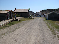
| Carissa Mine |
The next day's site seeing started with us heading south from Lander to South Pass City, passing through Atlantic City on the way. These were gold rush towns of the 1860s. Atlantic City isn't set up to tour buildings or sites so we didn't stop. There are still a few people that live in each of these tiny towns.
We got lucky at South Pass City and arrived right when they were opening the first tours of the restored Carissa Mine and Mill. This mine was the reason that South Pass City existed. They have pretty much rebuilt the buildings to replicate what was here during the boom days.
 |
| South Pass City from east to west |
After touring the mine and mill we headed into town where they have about 20 restored buildings and a lot of empty lots with signs indicating what establishment used to be there. Most of the buildings had fallen into disrepair but have been restored to very good replications of what they were.
The most impressive building, which looked like someone must have been keeping it maintained, was the South Pass Hotel and Restaurant. You are allowed to walk all throughout the building on the old, squeaky, uneven, plank floors and look in all the rooms which have period furniture and other artifacts. The actual front desk and kitchen were really neat. The next best one is the Saloon and card room in the next building. The saloon bar and furnishings look exactly like a photograph that they have for you to look at and compare. Link to the South Pass City website: http://www.southpasscity.com/
 |
| Sacajawea headstone center, left memorial to her son Baptiste (Pomp), right adopted son Brazil |
 |
| Statue of Sacajawea on shore of Pacific Ocean holding a Sand Dollar which she brought with her and gave to Chief Washakie |
 |
| Shoshone Indian Cemetery - it is so colorful with flowers (plastic), painted crosses, etc |
Informational plaques in the cemetery don't even agree on whether she is actually buried in the cemetery or if she was buried up in the Wind River mountains off in the distance. The hardest thing for me to believe about this version of the story is if she really died in 1884 she would have been 95 years old based on the Lewis and Clark Expedition writings indicating she was 16 in 1805. It doesn't really matter, it is still fun stuff. One thing that is consistently stated is this was her homeland, so that is cool enough for a visit.
If you're interested in the Sacajawea controversy, here is an interesting link I just found:
http://www.history.com/news/whos-buried-in-sacagaweas-grave
http://www.history.com/news/whos-buried-in-sacagaweas-grave


No comments:
Post a Comment