 |
| Chimney Rock |
From Lander we drove east across Wyoming and into western Nebraska. This is a very interesting region for Oregon Trail history. Most of the Oregon Trail is now on farmland and plowed under, or has a highway built over it, or has been naturally eroded away. We headed to the part of the country where there is a concentration of trail preservation. I'll describe our visit in the area from east to west as the pioneers would have traveled.
The pioneers spent 6 to 8 weeks crossing the great plains before getting to this area. Many described it is boring (they should be so lucky) and mentally difficult because of the monotony of the flat grasslands. Finally, they saw something sticking up on the horizon. Chimney Rock was a very welcome sight to them as it was an indication that they were nearing the end of the plains. If they only knew the rough country ahead. The state of Nebraska has a nice visitor center here with a great view from the same angle the pioneers would have.
 |
| Mitchell Pass |
 |
| Mitchell Pass |
About 20 miles to the northwest of Chimney Rock (at modern day Gering, NE) they came to Scotts Bluff. This is the name of the collective rock formations that spread for several miles. Originally the trail went south of the bluffs and across the Wildcat Hills at Robidoux Pass (pronounced roo-bi-doo). Eventually the Army assisted in making a passable trail, called Mitchell Pass, through the center of Scotts Bluff cutting off miles, time and hardship. The north end of Scotts Bluff around Mitchell Pass is now protected by the National Park Service as a National Monument. They have protected the trail through Mitchell Pass so you can see and walk on part of the trail. It was really neat to walk on the trail and see how they worked their way through the terrain.
 |
Mitchell Pass - left of the present day
walking path where the marker stake is |
 |
| Multi-lane ruts near Robidoux Pass |
It is estimated that over 500,000 pioneers traveled the trail. I haven't seen an estimate of the number of wagons but it was certainly significant. When they could, they would fan out rather than going single file to try to minimize how strung out their train was while eating less dust from a close wagon directly ahead. The picture to the right is of a place near Robidoux Pass just south of Gering Nebraska where you can see several lanes cut into the top of the hill. Also in the picture is a pioneer grave site that has a fence around it to protect it from the grazing cattle. I enjoyed walking around the field through the ruts (dodging cattle) trying to imagine the passing of a long string of wagons, cattle, some people walking and some riding.
 |
| Robidoux Trading Post |
A few miles away is a reconstructed trading post on the site of Robidoux Trading post. One of the first on the trail.
 |
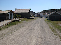
| Cavalry barracks |
The next stop that the pioneers had to look forward to was Fort Laramie another 65 miles to the northwest. Originally owned and operated by a fur trading company it was later purchased by the Army and converted to an Army fort with the purpose of protecting the pioneers and negotiating with the Indians. The fort was operated until 1890 when it was deemed no longer needed and was sold at public auction. Many of the buildings were dismantled but others were just left. The remaining buildings slowly fell into disrepair until eventually the National Park Service took over in 1937. They evaluated each building and those that were considered 80 percent sound were restored. The remaining buildings have just been maintained so they don't deteriorate any further.
 |
| Barracks lower floor mess hall |
Eleven buildings have been restored and furnished. They did a great job and we spent two hours walking around enjoying their work.
 |
| Barracks upper floor sleeping quarters |
Another 15 or 20 miles along, near present day Guernsey Wyoming (about 60 miles from the Nebraska border), is a National Historic Landmark where the trail is easily seen. In this location the trail climbed over a sandstone bluff along the Platte River and after thousands of wagons had done this over the years they gradually dug deep into the stone. These are some of the most prominent trail ruts still remaining 150 years after the trail stopped being used.
 |
| Ruts near Guernsey WY |
 |
| Ruts near Guernsey WY |
Just a few miles from the ruts near Guernsey is Register Cliff. This is a sandstone cliff along the Platte River where thousands of pioneers etched their names into the stone. Many of the etchings have eroded from the soft stone but hundreds still remain. We had a little stroke of bad luck here as they had a big section of the cliff fenced off while they did some maintenance on the path. We did see some of them so all was not lost.
 |
| Register Cliff etching |
Earlier in the week when we went to South Pass City in west central Wyoming, we were near a very important part of the trail because South Pass was where the trail went through the Rockies. There are supposedly some trail ruts there but they are off the beaten path and no one could tell us where to find them so we finally gave up trying.


